一觸即發
Oregon
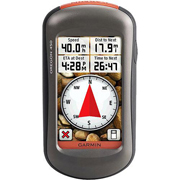
450率先採用堅固耐用的3英寸彩色觸摸屏,觸摸屏在日光下清晰易讀,提供清澈透明的增強顏色和高分辨率圖像。利用其易用界面,可減少搜索信息的時間,從而有更多的時間享受戶外活動。採用可由用戶選擇的控制板,可定制顯示器的外觀。
Oregon 450經久耐用,具有防水能力,可承受惡劣條件。顛簸、灰塵、污垢、潮氣和水對這種結實的導航器沒有任何影響。
更多探索
Oregon
450預裝配有渲染地貌的內置世界基圖。只需觸摸彩色屏幕方可開始導航。其數字高程圖以較高的放大倍數顯示渲染地貌,為您提供周圍地形的大畫面。
無線分享
使用Oregon
450,您可通過無線方式與其他兼容的Oregon、Colorado
和Dakota
用戶分享您的航點、航跡、航線和寶藏數據。現在,您可以把自己喜愛的遠足地點發送給朋友使用,或者發送待尋找的寶藏地點。共享數據輕而易舉。只需觸摸“發送”按鈕,就可把您的信息傳送給類似設備。
尋找樂趣
Oregon
450支持Geocaching.com
的GPX文件,可向您的設備直接下載寶藏和詳細信息。通過無紙方式訪問,您不僅幫助改善環境,還能提高效率。
Oregon存儲並顯示關鍵信息,包括地點、地形、難度、提示和說明,這意味著不再需要手工輸入坐標和在紙上打印輸出。只需把GPX文件上傳到您的設備,即可開始尋寶。使用Oregon的圖片查看軟件可展示您的遠足照片。
Oregon很輕薄,是您進行所有戶外活動的理想伴侶。
鎖定您的方位
Oregon
450 帶有內置3軸傾斜補償電子羅盤,即使在您靜止不動時,也會顯示您的朝向,無需水平放置。其氣壓高度表追踪壓力變化,可以指出您精確的海拔高度,甚至可以用它繪製氣壓隨時間變化的圖形,幫助您監控多變的天氣狀況。利用增強軌跡導航功能,您可查看前面地點和已去過地點的海拔高度。
Oregon 450配有高靈敏度、支持WAAS的GPS接收機和HotFix™
衛星預測功能,即使在茂密的森林或是深谷內也可快速精確地鎖定您的位置,並保持其GPS定位。
附加地圖
在地面或水上進行室外活動時,可方便地插入預裝microSD
卡(兼容地圖請參考地圖選項卡)。只需插入包含詳細街道圖的MapSource®
卡,Oregon
就會提供到達目的地以及各個轉彎方向。增加選定的地形圖可利用Oregon的三維地圖功能,從而更好地觀察海拔高度。利用BlueChart®
g2,您能夠獲得一切所需的水上活動,包括等深線、助航系統和港口數據。地圖卡槽位於防水電池盒的里面,您不用擔心防水問題。
自由連通
當您一直忙於探索環境,而想要儲存與分析您的活動項目,只要將Garmin
Connect™連接到您的電腦及互聯網,就可以詳細地分析您的活動。輕鬆地將路線發送至您的戶外設備上。使用Google™
Earth (谷歌地球)
一站式網站提供的活動表,便於您在地圖上看到及時活動信息,利用Garmin
Connect用戶上傳的上千萬的其它路線,在Twitter®和Facebook®上分享您的體驗。使用起來非常便捷,讓我們走出去、探索、分享吧。
Oregon
450:充分的與大自然接觸。
●
「觸摸屏」操作,可手寫輸入使得操作更便捷
● 6.5萬色TFT觸摸彩屏,超強防眩屏顯
●
支持數字高程模型圖和等高線圖
●
預裝最新城市詳圖,實現導航與路徑規劃功能
●
具氣壓計可實現準確的測高功能
●
支持數據無線分享
●
獨有的三軸電子羅盤,方位數據更精確
Touch and Go
Oregon
450 leads the way with a tough, 3-inch diagonal, sunlight-readable,
colour, touchscreen display that offers crystal clear enhanced colours
and high-resolution images. Its easy-to-use interface means you’ll spend
more time enjoying the outdoors and less time searching for information.
With user-selectable dashboards, you can customise the appearance of
your display. Both durable and waterproof, Oregon 450 is built to
withstand the elements. Bumps, dust, dirt, humidity and water are no
match for this rugged navigator.
Explore More
Oregon
450 comes with a built-in worldwide basemap with shaded contours. Simply
touch the colour screen to navigate. Its digital elevation maps show you
shaded contours at higher zoom levels, giving you a big picture of the
surrounding terrain.
Share Wirelessly
With
Oregon 450 you can share your waypoints, tracks, routes and geocaches
wirelessly other compatible Oregon,
Colorado and
Dakota users. Now you can send
your favorite hike to your friend to enjoy or the location of a cache to
find. Sharing data is easy. Just touch “send” to transfer your
information to similar units.
Find Fun
Oregon
450 supports
Geocaching.com GPX files for
downloading geocaches and details straight to your unit. By going
paperless, you're not only helping the environment but also improving
efficiency. Oregon stores and displays key information, including
location, terrain, difficulty, hints and descriptions, which means no
more manually entering coordinates and paper print outs! Simply upload
the GPX file to your unit and start hunting for caches. Show off photos
of your excursions with Oregon’s picture viewer. Slim and lightweight,
Oregon is the perfect companion for all your outdoor pursuits.
Get Your Bearings
Oregon
450 has a built-in 3-axis tilt-compensated electronic compass, which
shows your heading even when you’re standing still, without holding it
level. Its barometric altimeter tracks changes in pressure to pinpoint
your precise altitude, and you can even use it to plot barometric
pressure over time, which can help you keep an eye on changing weather
conditions. See changes in your elevation ahead of you and where you've
been with enhanced track navigation. With its high-sensitivity GPS
receiver and HotFix™ satellite prediction, Oregon 450 locates your
position quickly and precisely and maintains its GPS location even in
heavy cover.
Add Maps
Conveniently plug in optional preloaded microSD cards for all your
outdoor activities on land or water (see maps tab for compatible maps).
Just insert a MapSource® card with detailed street maps, and Oregon
provides turn-by-turn directions to your destination. Add optional
Garmin Australian topographic mapping to take advantage of Oregon’s 3-D
map view which gives you a better perspective of your elevation. With
BlueChart® g2 , you’ll get everything you need for a great day on the
water including depth contours, navaids and harbours. The card slot is
located inside the waterproof battery compartment, so you don't have to
worry about getting it wet.
Get Connected
You've
been busy exploring and now you want to store and analyse your
activities. With a simple connection to your computer and to the
Internet, you can get a detailed analysis of your activities and send
tracks to your outdoor device using
Garmin Connect™. This one-stop
site offers an activity table and allows you to view your activities on
a map using Google™ Earth. Explore other routes uploaded by millions of
Garmin Connect users and share your experiences on Twitter® and Facebook®.
Getting started is easy, so get
out there, explore, and share.
Oregon
450: Touch the great outdoors.